Sunday, February 1st, 2015
Stephan: This story is deep in the wonk weeds but no less important for that. Obama gets full marks for this. By compelling an account of sea level rise he forces it into the conversation, and deniers cannot shove it away. This is a good survey of the subject and I am not surprised it is in the Virginian-Pilot, a newspaper that services the Hampton Roads, including Norfolk and Virginia Beach which are already close to crisis because of sea rise. This large metropolitan area, with its two main cities has, through events, been forced to face the reality of climate change, and what is coming their way as a result of sea rise. They are going to lose whole neighborhoods, and they know it. What makes it even more painful is that much of this property is the most expensive real estate in the area.
As the report notes: "Last month, the National Oceanic and Atmospheric Administration predicted coastal areas will face 30 or more days of flooding by mid-century because of sea level rise. According to the National Climate Assessment, more than $1 trillion of property and structures in the United States are at risk of inundation from sea level rise of 2 feet above current sea level - an elevation that could be reached by that same point. "

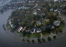
Norfolk Flooding Credit: michael-in-norfolk.blogspot.com
President Barack Obama on Friday signed an executive order requiring that all federally funded construction projects take into account flood risks linked to global warming. The order directs federal agencies to adopt stricter building and siting standards.
The executive order represents a major shift for the federal government: while the Federal Emergency Management Administration published a memo three years ago saying it would take global warming into account when preparing for more severe storms, most agencies continue to rely on historical data rather than future projections for building projects.
The new standard gives agencies three options for establishing the flood elevation and hazard area they use in siting, design and construction of federally funded projects. They can use data and methods “informed by best-available, actionable climate science”; build 2 feet above the 100-year flood elevation for standard projects and 3 feet above for critical buildings such as hospitals and evacuation centers; or build to the 500-year flood elevation.
The new policy does not make changes to the National Flood Insurance Program, which covers Americans in flood-prone areas with federally backed insurance provided […]


